Log in
All resources
Create a design
217 Free Artworks of Maps Showing History
the comprehensive history of england (1876)
english-language maps showing history
1870s maps showing history
bibliothèque nationale de france
philippe de la rué
1890s maps showing history
1650s maps showing history
picturesque burma, past and present (1897)
drawing
17th-century maps showing history
the comprehensive history of england (1876)
english-language maps showing history
1850s maps of the americas
maps by john tallis
the comprehensive history of england (1876)
english-language maps showing history
historisk atlas (stockholm, norstedt & söner, 1880)
maps of 13th-century germany
history of weißenfels
baroque
maps of ancient israel by philippe de la rué
map of modern syria by philippe de la rué
maps showing 19th-century history
isaiah thomas (publisher)
the comprehensive history of england (1876)
english-language maps showing history
the comprehensive history of england (1876)
english-language maps showing history
the comprehensive history of england (1876)
english-language maps showing history
the comprehensive history of england (1876)
english-language maps showing history
the comprehensive history of england (1876)
english-language maps showing history
the comprehensive history of england (1876)
english-language maps showing history
the comprehensive history of england (1876)
english-language maps showing history
the comprehensive history of england (1876)
english-language maps showing history
the comprehensive history of england (1876)
english-language maps showing history
the comprehensive history of england (1876)
english-language maps showing history
the comprehensive history of england (1876)
english-language maps showing history
the comprehensive history of england (1876)
english-language maps showing history
the comprehensive history of england (1876)
english-language maps showing history
the comprehensive history of england (1876)
english-language maps showing history
the comprehensive history of england (1876)
english-language maps showing history
the comprehensive history of england (1876)
english-language maps showing history
eran laor cartographic collection
maps by tomas lopez
the comprehensive history of england (1876)
english-language maps showing history
the comprehensive history of england (1876)
english-language maps showing history
the comprehensive history of england (1876)
english-language maps showing history
utagawa school,kasei culture,ukiyo-e
utagawa hiroshige
the comprehensive history of england (1876)
english-language maps showing history
map of ancient armenia by philippe de la rué
1650s maps of armenia
1830s maps of switzerland
1834 maps of europe
17th-century maps of moscow
16th-century maps of moscow
the comprehensive history of england (1876)
english-language maps showing history
the comprehensive history of england (1876)
english-language maps showing history
the comprehensive history of england (1876)
english-language maps showing history
the comprehensive history of england (1876)
english-language maps showing history
the comprehensive history of england (1876)
english-language maps showing history
the comprehensive history of england (1876)
english-language maps showing history
the comprehensive history of england (1876)
english-language maps showing history
the comprehensive history of england (1876)
english-language maps showing history
maps by pieter van der keere
maps by abraham ortelius
1720s maps showing history
1727 maps of africa
map of maastricht by willem and johannes blaeu (1649)
history of wyck (maastricht)
18th-century maps of new orleans
maps in the library of congress
maps by nicolaes visscher i
old maps of assyria
maps from the earth and its inhabitants, vol. vii
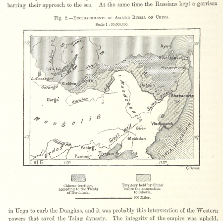
russian conquest of siberia
johann david schleuen
old maps of prussia
hierosolyma clarissima totius map by braun & hogenberg
latin-language maps showing history
antoine-françois tardieu
maps from gallica
maps by pieter van der keere
maps by abraham ortelius
description de l'universe
1680s maps of india
history of yokohama
maps of yokohama
map of maastricht by willem and johannes blaeu (1649)
history of wyck (maastricht)
old maps showing history of europe
description de l'universe
maps of europe by mercator-hondius
ateliers bmb mercator
maps by guillaume sanson
maps of galatia
maps of the history of jerusalem
1830s maps showing history
maps of the history of morocco
empire of morocco
1890s maps of the caribbean
brethren of the coast
nicolas desmarest
ambroise tardieu
old maps of st. augustine, florida
john white (colonist and artist)
old maps showing the history of the former colonies of france
cartes de franz schrader
19th-century maps of the british isles
arnold's geographical handbook (1899)
philippe de la rué
maps of troas
colonial history of the united states
old maps of new york (state)
map of ancient assyria by philippe de la rué
old maps of mesopotamia
redeeming the republic (1890)
1890s maps showing history
maps of the byzantine levant
1650s maps showing history
guillaume-nicolas delahaye
jacques martin
1840s maps showing history
maps by thomas starling
picturesque burma, past and present (1897)
1890s maps showing history
maps by jakob van der schley
old maps of southeast asia
historical collections of the state of new jersey (1852)
1850s maps of new jersey
geometrischer grundriss von frankfurt am mayn (1811)
untermainkai
maps in the library of congress
1770s maps showing history
robert gordon of straloch
1650s maps of scotland
map of ancient assyria by philippe de la rué
maps
maps of ancient italy by philipp clüver
maps of samnium
redeeming the republic (1890)
1890s maps showing history
historical collections of the state of new jersey (1845)
maps of newark, new jersey
picturesque burma, past and present (1897)
1890s maps showing history
picturesque burma, past and present (1897)
1890s maps showing history
picturesque burma, past and present (1897)
19th-century maps of myanmar
picturesque burma, past and present (1897)
1890s maps showing history
danubius pannonico-mysicus
luigi ferdinando marsigli
maps of ancient israel by philippe de la rué
old maps of ancient israel
atlas minor gerardi mercatoris (1609)
maps of asia by mercator-hondius
historical collections of the state of new jersey (1852)
maps of trenton, new jersey
maps of saint paul's journeys
maps by pieter van der keere
1805 maps of the united states
maps by john cary
stony brook, new jersey
battle of princeton
map of ancient armenia by philippe de la rué
maps of antony's parthian war
maps of the greek colonies
old maps of ancient greece
civitates orbis terrarum. urbium praecipuarum totius mundi. liber quartus
old maps of ancient rome (city)
travels in the interior of north america, during the years 1832–1834
works by maximilian zu wied-neuwied
civitates orbis terrarum. urbium praecipuarum totius mundi. liber quartus
16th-century maps showing history
civitates orbis terrarum. urbium praecipuarum totius mundi. liber quartus
16th-century maps showing history
maps by jakob van der schley
history of hormuz island
die baudenkmäler in frankfurt am main – band 3, privatbauten
template unknown (unspecified)
philippe de la rué
maps of mysia
101 - 200 of 217
Next page
/ 3


![Scotia antiqua, qualis priscis temporibus, Romanis praesertim, cognita fuit quam in lucem eruere conabatur / R. Gordonius a Straloch... [1653], 1654](https://cdn.creazilla.com/illustrations/10000806371/scotia-antiqua-qualis-priscis-temporibus-romanis-praesertim-cognita-fuit-quam-in-lucem-eruere-conabatur-r-gordonius-a-straloch-1653-1654-sm.jpg)


